Skip to content

Baseline Data: 2001-2011                                                                                                                        Last Updated: 2011
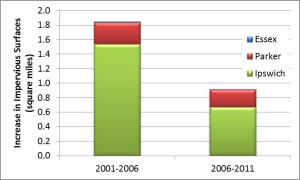
ImperviousTable

Increases in impervious surfaces in the PIE-Rivers region for 5-year periods between releases of the National Land Cover Database.

Impervious cover increases stormwater runoff and decreases infiltration often resulting in faster and higher (often referred to as “flashy”) peaks in streamflow following rainfall. Increased stormwater and decreased infiltration can also affect watersheds by increasing pollution loads in the river and decreasing groundwater contributions to streamflow (baseflow). Higher percentages of impervious cover in a watershed have been linked to decreased species richness and abundance of fluvial fish species in Massachusetts (D. S. Armstrong et al. 2011).


Map showing percent impervious surfaces for the PIE-Rivers region based on the 2011 National Land Cover Database (http://www.mrlc.gov/index.php)

References

Armstrong, D.S., Richards, T.A. & Levin, S.B., 2011. Factors Influencing Riverine Fish Assemblages in Massachusetts,

Back To Top